
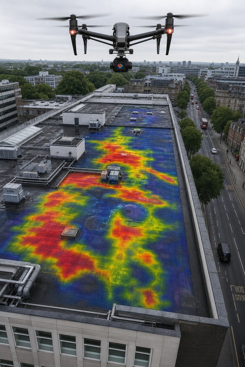
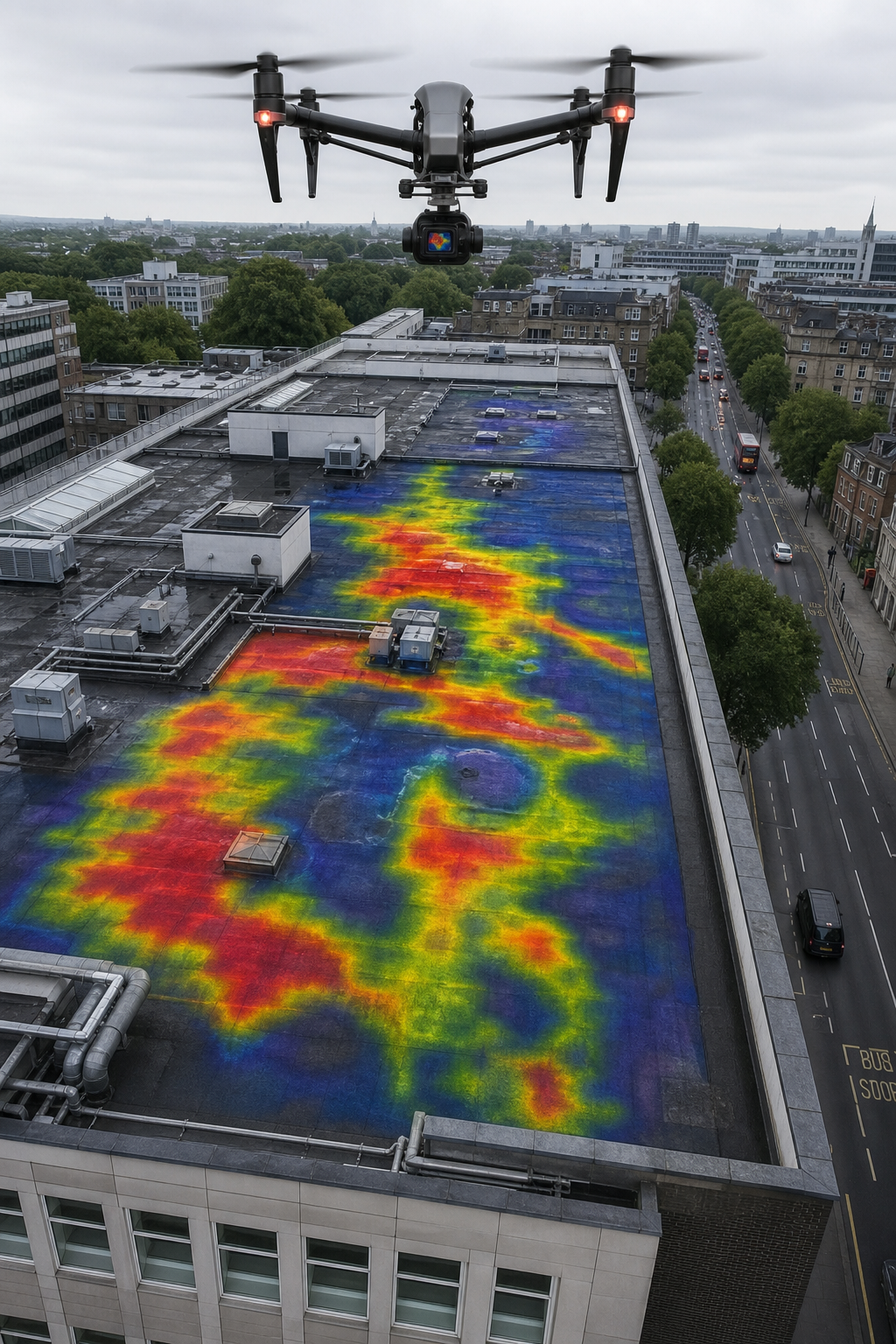
Imagine you could see through your building’s roof. Find hidden water damage, heat loss, and electrical faults without touching a single tile. That’s what drone thermal imaging does. It’s a game changer for commercial property managers, surveyors, and solar installers across the UK.
In this guide, we’ll explain what drone thermal imaging is, how it works, and why it’s becoming essential for commercial buildings. You’ll learn about key applications like flat roof inspections and solar PV thermography, compliance standards like IEC 62446, and how to choose the right provider. Let’s get started.
What Is Drone Thermal Imaging?
Drone thermal imaging is a technology that uses a camera mounted on a drone to see heat. Humans can’t see infrared radiation, but thermal cameras can. They turn heat into a picture. Warmer areas show up as bright spots, cooler areas as dark. That lets you spot problems the naked eye can’t see.
A drone with a thermal camera can scan a whole commercial roof in minutes. It’s safe, fast, and detailed. The camera measures temperature differences as small as 0.05 degrees. That’s important because early-stage issues often start with a tiny temperature change. A loose electrical connection might run just a few degrees hotter than normal. A thermal drone catches that.
According to a guide by ABJ Academy, the drone inspection market is growing fast. In 2024, it hit $16.4 billion and is expected to reach $38.2 billion by 2030. That’s because the technology works.
Think about a flat roof. Water can get trapped under the membrane. You can’t see it from the ground. But with thermal imaging, the wet areas retain heat differently. They show up clearly on a thermal map. No guessing. No cutting into the roof. Just a detailed report that tells you exactly where the problem is.
Bottom line: Drone thermal imaging gives you a heat map of your building, revealing defects that are invisible to the human eye, quickly and without risk.
Key Applications for Commercial Buildings
Drones with thermal cameras are useful for many types of inspections. Here are the most common ones for commercial buildings.
Flat Roof Inspections for Water Trapping
Flat roofs are prone to water ponding and moisture trapped under the membrane. Over time, water can cause leaks, rot, and structural damage. Traditional inspection means sending someone up to walk the roof. That’s dangerous and slow. With a drone, you can fly over the entire roof in one session. The thermal camera shows where water is trapped. The output is a thermal map of all defective areas. This takes the guesswork out of roof inspection.
This type of survey is especially important if you’re planning a solar panel installation on your commercial roof. Imagine installing solar panels, then finding roof defects later. You’d have to remove all the panels, fix the roof, and reinstall them. That would severely affect your return on investment. A drone thermal survey before installation avoids that cost.
Learn more about how drone roof surveys can protect your property investment.
Solar PV Thermography
Solar panels generate electricity, but they also heat up. Defective cells, bypass diode failures, or soiling cause temperature differences. A drone thermal camera can scan an entire solar array in minutes. It identifies hot spots, string failures, and potential fire risks. For commercial solar PV systems, regular thermal inspection is key to maintaining performance and safety.
According to Thermal Vision TX, thermal inspections of solar arrays can detect problems before they cause major energy loss or equipment damage. Early detection saves money on repairs and downtime.
Façade and Cladding Surveys
Building façades can hide insulation gaps, air leaks, and moisture. Drones with thermal cameras can scan tall buildings quickly, without scaffolding. This is ideal for high-rise blocks, hospitals, and universities. The thermal data shows where heat escapes, helping you prioritise energy efficiency improvements.
Bottom line: Whether it’s flat roof water detection, solar PV inspection, or façade analysis, drone thermal imaging delivers precise, actionable data for commercial buildings.
Compliance and Certification Standards
Not all drone thermal surveys are equal. For commercial buildings, especially those with solar PV systems, you need a provider that follows recognised standards. The most important one is IEC 62446.
IEC 62446 is an international standard for testing, documenting, and maintaining grid-connected photovoltaic systems. When you’re inspecting solar panels with drone thermal imaging, this standard ensures the results are reliable and accepted by warranty providers, insurers, and grid operators.
At Visual Perspectives, we are proud to advertise ITC Level 1 and 2 in Thermography, CAA compliance, and full compliance with IEC 62446. Our reports are actionable and meet the requirements expected by commercial solar installers and asset managers. As noted in a post by The Drone Life NJ, electrical equipment must be under load for effective thermography inspections. That’s why we schedule surveys when PV systems are generating. High load creates bigger temperature differences, making faults easier to spot.
Other standards you might encounter include BREEAM, UKTA, and BS EN ISO 6781-1:2023. These are good, but for solar PV, IEC 62446 is the gold standard. It’s the one that gives you confidence in the inspection data.
“The best time to inspect your solar array is before the warranty expires. IEC 62446 compliance ensures the inspection holds up to scrutiny.”
Bottom line: When hiring a drone thermal imaging provider, always ask for IEC 62446 compliance. It’s the mark of a serious, professional service for commercial solar PV inspections.
Benefits Over Traditional Inspection Methods
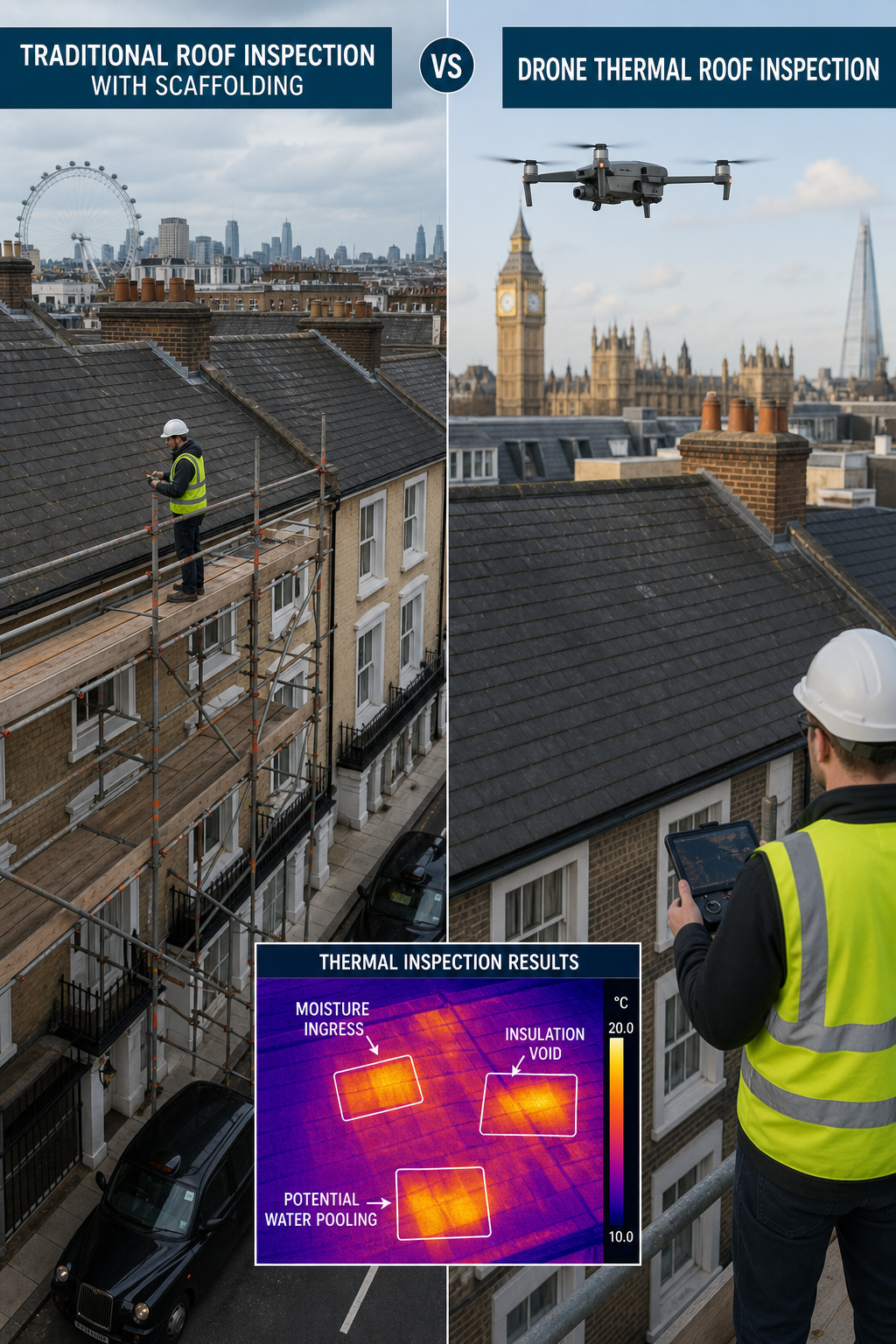
Traditional building inspections involve ladders, scaffolding, cherry pickers, and often working at height. They’re slow, expensive, and risky. Drone thermal imaging changes all that.
Think about a typical flat roof survey. In the past, you needed a team to erect scaffolding around the building. That could take days and cost thousands. Then an inspector would walk the roof, tapping and looking for soft spots. It was subjective and missed many hidden defects.
With a drone, one person can do the whole survey in a couple of hours. No scaffolding needed. No safety usees. The thermal camera captures every square metre of the roof. You get a complete thermal map. According to a cost comparison by Aerially AI, drone inspections can reduce building inspection costs by up to 50% compared to scaffolding methods.
Another big benefit is safety. Every year, workers are injured from falls on commercial roofs. By using a drone, you keep people on the ground. No one climbs a ladder or steps on a fragile roof surface. It’s simply safer.
Plus, you get better data. A traditional inspector might walk a roof and write notes. A drone survey produces high-resolution visual and thermal images, with GPS coordinates. You can zoom in on any defect and measure its size. The report is objective and repeatable. You can even compare surveys over time to track deterioration.
Bottom line: Compared to manual inspections, drone thermal imaging is faster, cheaper, safer, and provides objective, detailed evidence you can act on.
How to Choose a Commercial Drone Thermal Imaging Provider
Not every drone company offers the same level of service. For a commercial building, you need a provider with the right qualifications, equipment, and experience.
Start with certifications. Look for CAA permission, ITC thermography certification, and IEC 62446 compliance. Ask about their equipment. Do they use a radiometric thermal camera with at least 640×512 resolution? That’s the baseline for accurate measurement. Ask about their reporting. You want a detailed report with clear images, temperature data, and recommended actions.
Check their experience with commercial buildings. A provider that only does residential roofs may not understand commercial flat roof construction or solar PV systems. Look for case studies or testimonials from facility managers, surveyors, or energy managers.
At Visual Perspectives, we bring over 20 years of experience. We’re ITC Level 1 and 2 certified, CAA compliant, and fully insured with £5 million cover. Our reports are actionable and designed for asset managers, insurers, and solar installers.
For a deeper look at the technology used, explore our guide to drone roof inspections. It covers equipment and process in more detail.
Bottom line: Choose a provider with relevant certifications, commercial experience, and transparent reporting to get the most value from your drone thermal imaging survey.
FAQ
What is drone thermal imaging used for in commercial buildings?
Drone thermal imaging is used to detect heat-related issues in commercial buildings. Common applications include flat roof moisture surveys, solar PV panel inspections, façade heat loss detection, and electrical cabinet scans. It helps asset managers identify problems early, avoid costly repairs, and improve energy efficiency.
How accurate is drone thermal imaging?
Accuracy depends on the camera and setup. High-quality radiometric drones have a temperature measurement accuracy of ±2°C or ±2%. They can detect temperature differences as small as 0.05°C. Under proper conditions (low wind, stable ambient temperature), results are reliable for decision-making. Always use a certified thermographer for best results.
How long does a drone thermal survey take?
A typical commercial roof survey takes 1-3 hours depending on building size. Larger sites like solar farms may take half a day. The drone covers the area quickly. After the flight, the data is processed into a report. Total turnaround time from flight to report is usually 2-3 business days.
Do you need to have the solar panels running during a thermal inspection?
Yes. For solar PV thermography, panels must be under load (producing electricity) to generate heat in defective cells. Inspections are usually done midday when irradiance is high. That ensures maximum temperature contrast between healthy and faulty areas.
Is drone thermal imaging expensive?
Compared to traditional methods like scaffolding or cherry pickers, drone thermal imaging is often cheaper. For a flat roof survey, drone inspection can save 50% or more. The investment is offset by early defect detection, reduced risk, and detailed data that supports maintenance planning.
What standards should a provider comply with?
For commercial solar PV, the key standard is IEC 62446. For general building thermography, look for ISO 6781 compliance. In the UK, providers should also hold CAA permission for commercial drone operations, and thermographers should have ITC certification.
Can drone thermal imaging detect water in flat roofs?
Yes, it’s one of the most effective methods. Water has a different thermal capacitance than dry insulation. As the roof heats and cools, wet areas show a temperature lag. A thermal drone captures this pattern, producing a clear map of moisture distribution without damaging the roof membrane.
How do I prepare my building for a drone thermal survey?
Ensure clear access to the drone launch area. For roof surveys, clear any loose items. For solar PV, make sure panels are operating normally. The provider will advise on scheduling best times. Generally, surveys are done at dusk or dawn for roof moisture, and midday for solar panels.
Conclusion
Drone thermal imaging is transforming how commercial buildings are inspected. It’s faster, safer, and more thorough than traditional methods. For flat roofs, it spots trapped water before leaks cause damage. For solar PV, it ensures your investment performs as expected. And with standards like IEC 62446, you can trust the results.
If you’re a facility manager, surveyor, or solar installer looking to improve your inspection process, consider partnering with a qualified drone thermal provider. We’re here to help. Our team at Visual Perspectives has the certifications, equipment, and experience to deliver surveys that are quickly, precise, and detailed. Contact us to discuss your next project.
Remember, what the naked eye can’t see can cost you thousands. With drone thermal imaging, you see it all.

