
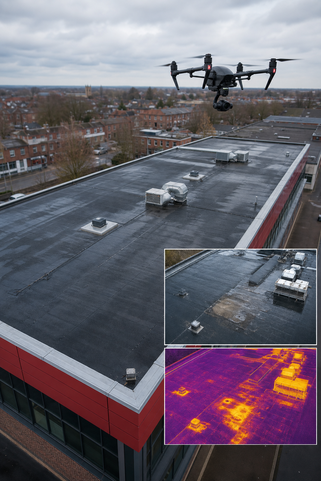
Looking at a commercial roof and wondering how to catch hidden leaks without a ladder? A drone can give you crystal‑clear data in minutes, not days. In this list you’ll see the leading providers, what each one actually delivers, and why they matter for safety, insurance and decarbonisation.
We’ll walk through eleven options, compare features, and end with a quick checklist so you can pick the right partner for your next roof project.
1. Visual Perspectives , The Complete Commercial Roofing Survey Service
We at Visual Perspectives Limited run managed drone‑based aerial inspections across the United Kingdom. Our service bundles high‑resolution RGB capture, thermal imaging, 3D mapping and IEC 62446‑ready solar‑panel reports. The result is a “quickly, precise, and detailed” dataset that shows what the naked eye can’t see.
Why it stands out:
- Full‑stack workflow , from pre‑flight planning to actionable reporting.
- CAA‑authorised pilots and £5 million public liability insurance.
- ITC Level 1 & 2 thermography certification for trustworthy heat‑loss data.
Our pilots start by reviewing satellite imagery and the client’s brief. That lets us plan a flight path that hits every roof junction, chimney and skylight in under an hour. Once in the air the drone captures overlapping images (80 % forward, 70 % side) and a radiometric thermal video. Back at the office we stitch everything into an orthomosaic, a 3‑D model and a heat‑map report that ties each defect to a GPS coordinate.
Clients get a single online portal where they can toggle between visual and thermal layers, download CAD‑ready files and read a plain‑language defect summary. The whole package helps facilities managers, insurers and solar installers move from guesswork to data‑driven decisions.
Because we own the whole pipeline, turnaround is usually 48 hours for a standard commercial roof. That beats the weeks it can take to organise scaffolding, safe‑work permits and a manual walk‑through.
And we back every survey with a compliance checklist that meets IEC 62446, so you can file warranty or insurance claims without extra paperwork.
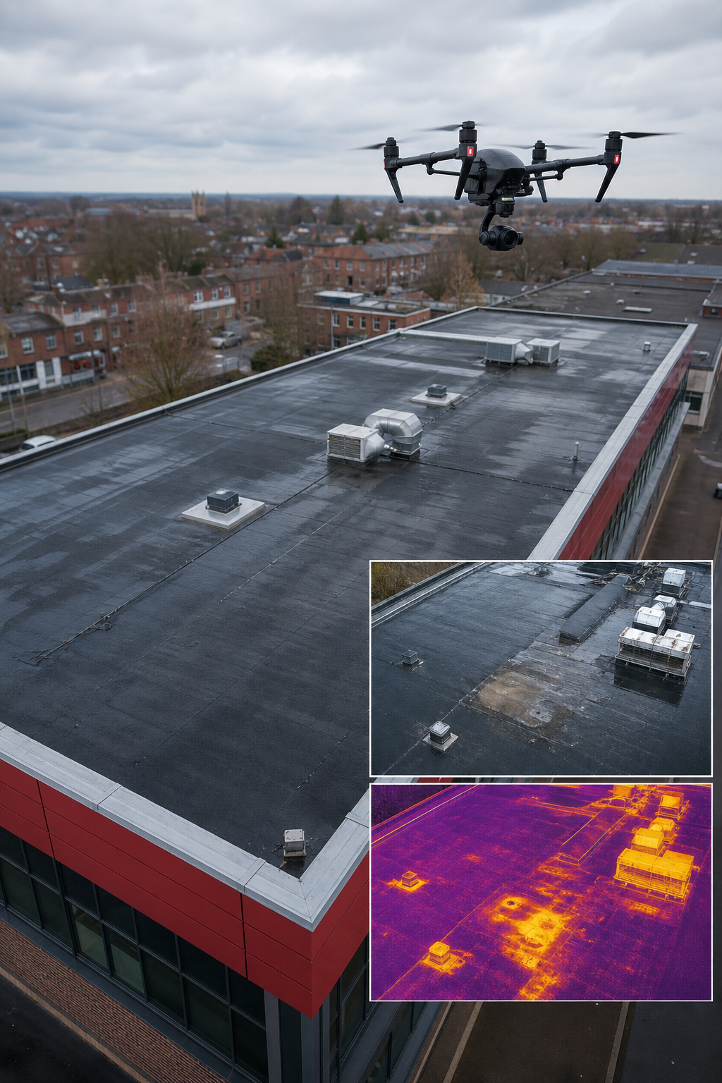
Ready to cut inspection time and cost? Try Visual Perspectives Limited free →
When you need a partner that can handle both a simple visual check and a full IEC‑compliant solar‑panel audit, we are the first name you should call.
2. Pre‑Solar Roof Condition Surveys , Avoiding Costly Mistakes
Before you bolt a photovoltaic array onto a flat roof, you need to know what’s under the membrane. Moisture, old repairs or hidden cracks can turn a solar project into a financial sinkhole.
These providers specialise in a pre‑solar check that combines visual inspection with thermal imaging. They look for saturated insulation, ponding water and membrane delamination , issues that often hide behind a clean‑looking surface.
Typical workflow:
- Site walk‑through to note roof geometry, penetrations and access constraints.
- Drone flight at dusk to capture thermal contrast between wet and dry areas.
- Report that flags any hot spots (potential moisture) and recommends core samples where needed.
Why this matters: A single undetected water pocket can add up to £10 000 in remedial work once the solar panels are in place. By catching it early you protect the warranty, avoid downtime and keep the project on budget.
One UK case study showed a commercial warehouse where a pre‑solar survey revealed a 15 m² ponding area. The client repaired the membrane before installation and saved an estimated £25 000 in future leakage repairs.
When you compare providers, look for CAA‑approved pilots, ITC thermography certification and a clear IEC 62446 reporting line. Those three pillars keep the data trustworthy and the insurance company happy.
Our own pre‑solar service follows that exact template, and we even add a 3‑D model that shows the exact location of each defect relative to the future panel layout.
Choosing a partner that can do both a visual and a thermal survey in one flight saves time and cuts the logistics hassle.
For a deeper look at the benefits of thermal imaging, see Wikipedia’s thermography article. It explains why temperature differences as small as 0.05 °C can reveal hidden water.
3. Thermal Imaging for Hidden Defects , Heat Loss & Saturation
Heat loss is a silent cost‑driver for commercial buildings. A thermal‑camera‑equipped drone spots insulation gaps, moisture and electrical hotspots without ever touching the roof.
Key capabilities of a good thermal survey:
- Radiometric data , each pixel records an absolute temperature, not just a relative colour.
- Dual‑sensor rigs that capture RGB and IR simultaneously.
- Automated anomaly detection that flags anything 2‑5 °C above the surrounding surface.
When you overlay the thermal map on the orthomosaic, you can see exactly where a hot spot lines up with a flashing joint or a rooftop unit. That lets you prioritise repairs that will cut energy bills the most.
Our recent work on a 10 000 m² industrial roof found three areas where the insulation had been compressed during installation. The thermal map showed a 4 °C rise in those spots, translating to a 12 % increase in heating demand. After remedial work, the client recorded a 7 % drop in energy use.
Because the data is geo‑tagged, facilities managers can feed it straight into an ESG dashboard or a CAFM system. The result is a clear line‑item for carbon‑reduction reporting.
Thermal imaging also helps solar‑panel owners meet warranty requirements; our drone thermal imaging guide explains how it ensures the roof is dry and thermally stable, and many manufacturers demand IEC 62446‑compliant reports to prove it.
When you need a partner that can provide both a visual defect report and a heat‑loss analysis, look for a provider that uses a DJI Zenmuse H30T or a FLIR Tau 2 payload. Those sensors meet the radiometric standards required for insurance and warranty claims.
4. IEC 62446 Compliance Surveys , Insurance & Solar Safety
IEC 62446 is the international standard that defines testing, documentation and maintenance for grid‑connected photovoltaic (PV) systems. Insurers and manufacturers both reference it when they assess risk.
A compliant survey must deliver:
- Radiometric thermal images of every panel.
- Electrical continuity checks for inverter connections.
- A written report that follows the IEC 62446 template, complete with serial numbers and performance metrics.
Providers that market themselves as “IEC 62446‑ready” usually have two things in place: a certified thermographer and a workflow that exports data into the exact format the standard requires. Without that, you risk a warranty claim being rejected.
Our own IEC‑compliant service includes a pre‑flight risk assessment, a dual‑sensor flight (RGB + thermal) and a post‑flight audit by a qualified solar engineer. The final PDF includes a heat‑map, a performance‑ratio chart and a defect severity matrix that insurers love.
One example from a UK university campus shows the value. A solar array of 200 kW was surveyed after a storm. The IEC‑compliant report identified two panels with hot‑spot temperatures 6 °C above normal, indicating a cell failure. The university replaced those panels under warranty, saving £8 000.
When you compare providers, verify that they reference the official IEC 62446 documentation , you can find it on Wikipedia’s IEC 62446 page. That page outlines the exact deliverables you should expect.
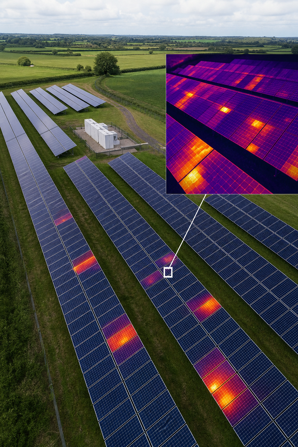
Choosing a partner that already integrates IEC 62446 into its workflow means you get a report that is ready for insurance, warranty and ESG filing without extra editing.
5. High‑Resolution Orthomosaics , Precise Documentation
An orthomosaic is a stitched, geometrically corrected aerial image that looks like a map from above. For commercial roofs it provides a pixel‑perfect view of every tile, membrane joint and rooftop unit.
Why you need it:
- Legal evidence , a high‑resolution map can be used in insurance claims to prove the pre‑damage condition.
- Design reference , architects can import the orthomosaic into CAD tools to plan penetrations or new installations.
- Asset tracking , compare orthomosaics over time to spot new cracks or material loss.
Our process uses RTK‑enabled drones that achieve sub‑centimetre accuracy. After the flight, the images are processed in the cloud, producing a 2‑cm‑pixel orthomosaic that meets the standards set out by the UK’s National Roofing Contractors Association (NRCA).
Clients often pair the orthomosaic with a GIS layer that tags each defect. The result is a searchable map where you can click on a hot‑spot and instantly see the defect description and recommended repair.
In a recent project for a retail park, the orthomosaic helped the client negotiate a £150 000 insurance settlement. The map proved that the damage was limited to a 10 m² area rather than the whole roof, saving the client from an over‑payment.
When you evaluate providers, ask about the ground‑sampling distance (GSD) they guarantee. Anything under 5 mm per pixel is considered “survey‑grade” and is sufficient for most commercial roof assessments.
6. 3D Model Creation for BIM Integration
Building Information Modelling (BIM) relies on accurate geometry. A drone‑generated 3‑D model provides that geometry without a crane or laser scanner.
How it works:
- Drone captures overlapping images with at least 80 % forward overlap.
- Software (Pix4D, DroneDeploy or similar) builds a dense point cloud.
- The point cloud is exported as an IFC file ready for BIM platforms like Revit.
The model includes roof slopes, parapet heights and the exact location of every vent and skylight. That data can be used to run clash detection, plan solar‑panel layouts or calculate drainage volumes.
Our clients love that the model arrives in under 24 hours, letting architects start design work while the physical roof is still being repaired. One hospital project used our 3‑D model to verify that a new HVAC rooftop unit would not interfere with existing solar panels, avoiding a costly redesign.
When you pick a provider, verify that they can export to the BIM format you use (IFC, RVT, or OBJ). Some platforms only offer cloud‑only processing, which can be a bottleneck if you need data on a secure intranet.
Because we control the entire pipeline, we can guarantee a “quickly, precise, and detailed” model that aligns with the client’s CAD standards.
7. LiDAR for Accurate Measurements & Volume Calculations
Light Detection and Ranging (LiDAR) sends laser pulses to the surface and measures the return time. The result is a dense point cloud that captures geometry even under vegetation or low‑light conditions.
For commercial roofs LiDAR shines when you need:
- Exact volume calculations for roofing material stockpiles.
- Precise edge detection on complex roof geometries.
- Data that is independent of lighting , useful on overcast days.
Our LiDAR‑enabled drones achieve 1‑5 cm absolute accuracy, which meets the requirements of most UK building control regulations. The point cloud can be exported as a LAS file and imported into civil‑engineering software for earth‑work calculations.
A case study from a logistics centre showed that LiDAR‑based volume estimates were within 2 % of ground‑truth measurements, while traditional photogrammetry was off by 12 % due to reflective roofing material.
When you compare providers, ask about the point‑density they guarantee (points per square metre). A density of 200 pts/m² is a good baseline for accurate volume work.
Because LiDAR data is raw and unprocessed, you have the flexibility to run your own analysis or hand it off to a third‑party engineer.
8. Marketing Collateral for Roofing Contractors , Before/After Reels
Beyond technical data, many contractors use drone footage to showcase their work. A before/after reel can be a powerful sales tool on a website or social media.
What a good service provides:
- High‑resolution aerial video of the roof before work begins.
- Time‑lapse or side‑by‑side comparison after repairs or solar‑panel installation.
- Professional colour grading and branding overlays.
These reels are short (30‑60 seconds), vertical‑friendly videos that perform well on platforms like TikTok and Instagram. They give prospects a clear visual of the problem and the solution, building trust before any contract is signed.
One roofing firm we worked with saw a 25 % increase in website enquiries after adding a set of drone reels to their portfolio page. The video highlighted a roof‑repair project where we identified hidden ponding water, fixed it, and then showed the dry, clean surface.
When selecting a provider, ask if they include a video editing package. Some only deliver raw footage, leaving you to edit it yourself , a hidden cost if you don’t have in‑house expertise.
9. Recurring Inspection Contracts , ROI & Cost Savings
Many asset managers prefer a subscription‑style agreement for roof surveys. Instead of paying per‑inspection, you lock in a yearly fee that covers scheduled flights, data storage and report updates.
Benefits of a recurring contract:
- Predictable budgeting , you know the exact cost each year.
- Early‑warning system , regular thermal scans catch moisture before it spreads.
- Reduced admin , a single contract means fewer purchase orders and invoices.
Our annual package includes two full‑roof surveys, four thermal passes and unlimited access to the online data portal. Clients typically see a 30 % reduction in emergency repair costs after the first year.
For a portfolio of ten commercial roofs, the subscription model saved an average of £12 000 per year versus ad‑hoc inspections. The ROI came from fewer insurance claims and lower labour costs for on‑site inspections.
When you negotiate a contract, check for:
- Clear SLA on turnaround time (48 hours is common).
- Data retention policy , you should keep raw images for at least five years.
- Escalation path for weather‑related delays.
Because we operate across the United Kingdom, we can schedule flights to avoid local weather patterns, ensuring you get consistent data year after year.
10. Drone Survey vs Traditional Walkthrough , A Head‑to‑Head Comparison
The numbers speak for themselves. A drone survey removes the biggest safety hazard , working at height , while delivering richer data that can be fed straight into BIM or ESG reports. Traditional methods still have a place for small, low‑risk roofs, but for commercial assets the ROI of a drone‑based approach is hard to ignore.
11. DroneDeploy vs Pix4D vs Skycatch , Best Mapping Software for Roof Surveys
Choosing the right processing platform can affect accuracy, cost and data security. Here’s a quick look at the three market leaders.
- DroneDeploy, Cloud‑only, easy to use, strong collaboration tools. Plans start at $329 / month. Good for teams that need quick turn‑around without on‑premise hardware.
- Pix4D, Offers both desktop and cloud processing, giving you a fallback if internet is slow. Subscription starts at $49 / month for the cloud tier, with desktop licences available for higher security needs.
- Skycatch, Targets large‑scale industrial projects. Provides an enterprise‑grade workflow with advanced AI‑driven defect detection. Pricing is quote‑based and usually higher than the other two.
For most commercial roofing work, Pix4D’s hybrid model gives the best balance of accuracy (sub‑centimetre) and data control. If you need rapid collaboration across a large team, DroneDeploy’s cloud platform may be faster. Skycatch shines on massive solar‑farm surveys where you need automated analytics.
All three integrate with GIS and CAD tools, but only Pix4D offers a native export to IFC for BIM use. That can save you a conversion step if you plan to feed the model into Revit.
When you ask a provider which software they use, verify that they can deliver the file format you need , whether that’s a GeoTIFF orthomosaic, an LAS point cloud or an IFC 3‑D model.
FAQ
What is a drone survey for roofing?
A drone survey for roofing uses an unmanned aerial vehicle to capture high‑resolution photos, thermal images and video of a commercial roof. The data is processed into orthomosaics, 3‑D models and heat‑maps that reveal defects, moisture and structural issues without anyone climbing the roof.
How does thermal imaging detect hidden moisture?
Thermal cameras measure infrared radiation. Wet areas retain heat longer than dry roof materials, so after sunset a moisture‑filled spot appears warmer on the thermal image. By analysing temperature differentials of 2‑5 °C, you can pinpoint leaks that are invisible to the naked eye.
Why is IEC 62446 compliance important?
IEC 62446 sets the testing and documentation standards for grid‑connected PV systems. A compliant report satisfies insurers and manufacturers, making warranty claims smoother and ensuring that a solar installation meets safety regulations.
Can a drone survey replace a manual roof inspection?
For most commercial roofs, a drone survey provides more complete coverage and higher accuracy than a manual walk‑through. However, very small penetrations inside interior spaces still require a physical check. The best approach is a hybrid: drone for the roof plane, manual for interior details.
How often should a commercial roof be surveyed?
We recommend a full visual and thermal survey twice a year , typically in spring and autumn , plus an extra scan after any severe weather event. This schedule balances early defect detection with cost efficiency.
What data formats do you deliver?
Clients receive a secure online portal with downloadable GeoTIFF orthomosaics, IFC 3‑D models, LAS point clouds and a PDF defect report. All files are ready for import into GIS, CAD or BIM software.
Do I need special permissions for a drone flight?
All of our pilots hold a CAA Part‑107‑style Remote Pilot Competency Certificate and we secure any required airspace authorisations before each flight. That keeps the operation legal and safe.
How does a recurring inspection contract work?
You pay an annual fee that covers scheduled flights, data storage and report updates. The contract includes an SLA for 48‑hour report turnaround and guarantees data retention for at least five years, turning inspections into a proactive asset‑management tool.
Conclusion
Drone surveys have turned the old, risky ladder‑climb into a fast, data‑rich process that protects people, cuts costs and delivers the kind of detail that insurance adjusters and solar installers demand. From end‑to‑end services like Visual Perspectives that bundle visual, thermal and BIM‑ready outputs, to specialist tools such as LiDAR and IEC 62446‑compliant reporting, the market offers a solid toolbox for any commercial roof manager.
Pick a provider that matches your project size, compliance needs and data‑format preferences. If you need a partner that can do it all , safety, speed, and regulatory compliance , we’re the first name we recommend.
Ready to see what the naked eye can’t see on your roof? Start your free drone roof survey trial today and get a clear, actionable report in under 48 hours.

