
Drone roof inspection services provide a practical way to assess large or difficult-to-access roofs without relying immediately on ladders, scaffolding or powered access. They can produce clear visual evidence efficiently, while reducing work at height and helping estates teams target further investigation. Visual Perspectives Limited provides managed drone-based aerial inspections across the UK, including roof and façade surveys, 3D mapping and thermal imaging where the inspection brief requires it. Below, we explain what the service covers, how reliable survey evidence is gathered, where it fits within asset-management workflows, and what decision makers should check before commissioning an inspection.
What Drone Roof Inspection Services Actually Cover
A typical drone roof survey captures high‑resolution stills and video of every roof element, including tiles, slates, flashings, gutters, rooflights and penetrations, from multiple angles. The images can be stitched into orthomosaics that let you pan across the whole surface as if you were standing on the roof. Some providers supply geotagged imagery, so you can relate a recorded defect to its position on the roof. Drone roof inspection information can help explain the process.
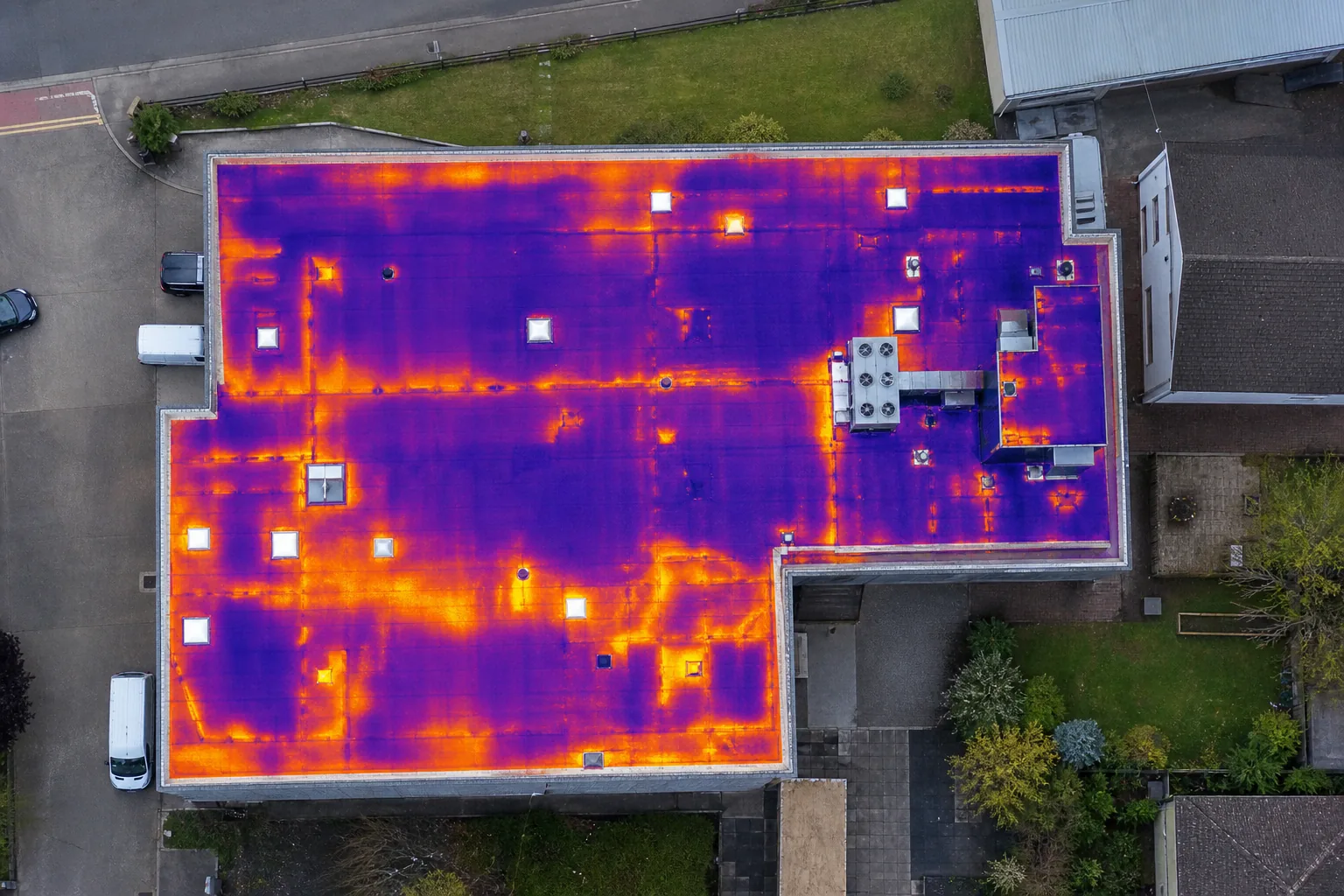
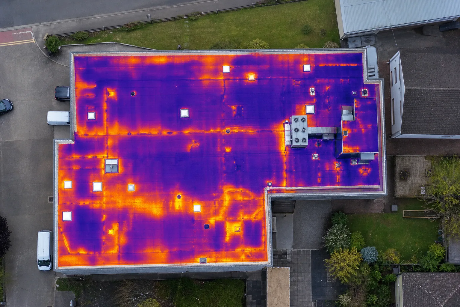
Beyond plain visuals, many providers add thermal imaging to spot temperature differences that hint at moisture, missing insulation or heat loss, the kind of issues you can’t see with the naked eye. The thermal data is over‑laid on the orthomosaic, letting you see a hot‑spot map in the same file as the visual map.
Reports usually include:
- Annotated images that point out cracked tiles, displaced flashings, blocked gutters and other visible faults.
- A heat‑loss diagram if thermography was used.
- An urgency rating (high, medium, low) that helps you prioritise repairs.
- Recommendations for further investigation, such as core sampling or on‑site inspection.
Because the drone never touches the roof, the method works well on heritage slate, asbestos‑capped roofs or large flat roofs where scaffolding would be disruptive. The data can be handed to building surveyors, facilities managers or insurers as a compliant evidence package.
While the images are precise, a drone can’t confirm hidden timber rot, membrane adhesion problems or the exact path of water ingress. Those conditions still need a physical inspection or core sampling to verify.
Regulations also matter. In the UK, commercial UAV operations require appropriate flight authorisations and insurance, and imagery should be handled carefully where private spaces are visible.
How a Professional Roof Drone Survey Produces Reliable Evidence
First, the survey team conducts a pre‑flight risk assessment. They map out the site, check wind speed, identify nearby power lines and confirm any exclusion zones with the local authority. The plan is filed with the relevant aviation authority and the client, so everyone knows the flight path.
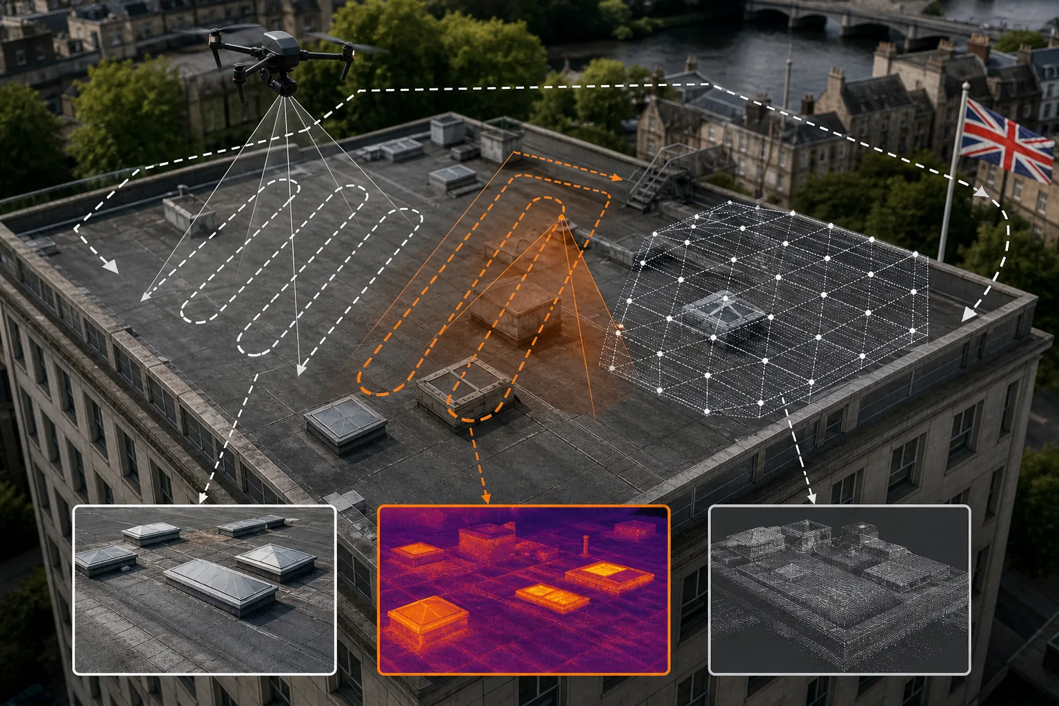
During the flight, the drone follows GPS‑guided waypoints that ensure complete coverage. Overlap of 70‑80 % between images enables the photogrammetry software to stitch a consistent 3‑D model. The model is georeferenced to the building’s BIM or CAD files, so you can measure slopes, heights and distances directly in the model.
Thermal sensors capture infrared data at the same time. To obtain reliable temperature readings, the survey is scheduled for early morning or late afternoon when solar loading is low, and the drone’s onboard radiometer is calibrated against a known reference plate.
After the flight, the raw data is processed on a secure workstation. The software extracts defect markers, generates an orthomosaic, builds the 3‑D mesh and merges the thermal overlay.
The final report bundles the visual evidence, the thermal map, a defect register and recommendations that reference relevant standards such as IEC 62446‑3 for photovoltaic‑related roof work and PAS 2035 for retrofit.
Because the evidence is timestamped and geo‑tagged, insurers can use it to support claims assessment, while asset managers can link the findings to a maintenance schedule in CMMS software.
Our own team at Visual Perspectives Limited follows this exact workflow, backed by over £5 million liability insurance and appropriately authorised pilots.
What Drones Can and Cannot Reveal About Roof Condition
Drones excel at spotting surface‑level problems. Missing or cracked tiles, displaced flashings, blocked gutters, ponding water and obvious corrosion are all visible in the high‑resolution orthomosaic. Thermal imaging adds another layer: a cold spot on a flat roof often points to moisture trapped behind the membrane, while a hot spot can indicate missing insulation or heat bridges.
What drones can’t see are the internal failures that hide behind the outer skin. Timber decay, delaminated insulation, hidden rust in steel brackets, or the exact route of water travelling through a cavity wall remain invisible until you open the roof or take core samples. For that reason, most survey reports flag any thermal anomaly as “requires further investigation” rather than “defect confirmed”.
Another limitation is weather‑dependence. Heavy rain, high winds or low contrast (e.g., a dark roof on an overcast day) can degrade image quality. Skilled pilots will postpone the flight until conditions improve, which adds a small scheduling buffer.
Finally, drones respect privacy. The camera’s field of view is limited to the roof envelope; operators must avoid capturing neighbouring houses or private gardens unless expressly required and covered by a data‑protection impact assessment.
Overall, a drone provides a rapid, safe snapshot that tells you where to look more closely. It’s the first step in a layered inspection strategy that moves from “what we see” to “what we need to verify”.
Selecting the Right Inspection Scope and Deliverables
Every project is different, so you need to match the survey scope to the decision you have to make. A simple visual check might be enough for a routine maintenance review, while a full 3‑D model with thermal analysis is required for PSDS Phase 4 funding applications or insurance claims.
Typical scope options include:
- Basic visual survey: Orthomosaic and annotated defect list, ideal for quick condition checks.
- Thermal‑enhanced survey: Adds heat‑loss mapping, useful for energy‑efficiency studies and moisture detection.
- 3‑D CAD/BIM‑ready model: Point‑cloud data that can be imported into design software, essential for retrofit planning.
- Full compliance package: IEC 62446‑3 certification, detailed thermal report, U‑value calculations and a risk‑graded defect register, required for public‑sector funding bids.
When you define the scope, ask yourself:
- What is the primary decision? (e.g., budgeting repairs, applying for funding, meeting insurance requirements.)
- Do I need thermal data to prove heat loss?
- Will the model be used for design work later?
- What is my budget and timeline?
Pricing varies with complexity and is available on request. Published UK market guidance indicates that the scope, roof size, access requirements and reporting detail are the main factors affecting cost.
Visual Perspectives Limited’s service packages are built around these same tiers. We start with a clear brief, then propose the most efficient deliverable set, whether you only need a defect register or a full IEC‑compliant report ready for PSDS Phase 4.
Turning Roof Inspection Findings into Asset Management Decisions
Once the report has been reviewed, the next step is to transfer the findings into your asset-management system. Most modern CMMS platforms accept CSV imports, allowing the defect register to be uploaded directly. Each defect can be tagged with a location code, severity rating and recommended action, making it easier to schedule work orders and allocate resources.
Thermal anomalies can also be linked to energy-performance dashboards. By converting the heat-loss map into a U-value estimate, you obtain a quantitative indication of how much additional heating demand the roof may be creating. This information can help prioritise insulation upgrades and support decarbonisation planning in line with Net Zero targets.
For public-sector estates, the evidence package can support the requirements of PSDS Phase 4. IEC 62446-3 certification demonstrates that the thermal survey was undertaken against a recognised standard, while the 3-D model supports a “building fabric first” approach, as advocated by CIBSE. The findings should still be interpreted alongside drawings, intrusive investigations and other available building information.
Insurance adjusters also benefit from timestamped, geo-referenced photographs. If a storm causes damage, the pre-storm orthomosaic can be compared with post-storm imagery to help establish the extent, location and likely timing of deterioration.
Finally, the visual record provides a baseline for future condition monitoring. Repeating a drone survey every two to three years can help track defect progression, verify whether repairs have been effective and adjust maintenance budgets using observed trends rather than assumptions.
In short, a drone survey is not an end in itself. It provides a structured evidence base that supports the move from reactive repairs to planned, risk-based asset management.
Frequently Asked Questions About Drone Roof Inspections
What qualifications and permissions does a drone operator need in the UK?
The operator must comply with current aviation requirements for the aircraft and proposed operation. Depending on the risk assessment, higher-risk work may require a CAA Operational Authorisation. The operator should also complete site-specific airspace, privacy and safety checks before flying.
Can a drone survey replace a full roof inspection?
A drone provides a high-level visual and, where suitable, thermal overview, but it cannot confirm hidden timber decay, membrane adhesion issues or the exact path of water ingress. Those concealed problems may still require a physical inspection, opening-up works or core sampling.
How long does a typical commercial roof survey take?
From planning to final report, many commercial projects can be completed within 5–7 working days, subject to weather, site access and scope. Flight time is often under an hour; data processing, thermal review and reporting generally take the bulk of the time.
Is the data secure and properly managed?
It should be. A responsible provider stores imagery securely, restricts access to authorised personnel and retains personal data only for as long as required by the project brief and applicable data-protection obligations. Privacy controls should be agreed before any flight near occupied buildings or public areas.
Do I need special insurance for the drone operation?
Professional operators should hold appropriate aviation and public liability insurance for the aircraft, site and proposed work. The required cover depends on the operation and aircraft weight; clients should request evidence of valid insurance and confirm that it covers commercial roof inspection activities.
Conclusion
If you need reliable, safe and cost‑effective roof evidence, a drone survey is the right first step. It gives you visual and thermal data, a GPS‑linked defect register and, when required, an IEC‑compliant report that satisfies public‑sector funding rules.
Contact Visual Perspectives to discuss the exact scope you need and to get a fixed, transparent quote. Our Services | Thermography and Drone Inspection are designed to feed straight into asset‑management workflows, helping you plan repairs, meet compliance and support decarbonisation targets.

